
Exciting News! We’re thrilled to announce the release of CoMaps to Google Play Store, Apple App Store, and F-Droid!
CoMaps Highlights
· Offline Search and Route: Plan and navigate your trips without internet
· Saves battery: Efficient design that does not drain your battery
· Privacy-respecting: no identify people, no tracking, no data collection
· Free and No Ads: completely free, your journey is smooth
What makes CoMaps special?
CoMaps is a community-driven open-source navigation app · Open & Transparent: All decisions are made in public, with full transparency.
· Community Empowerment: You have a voice in how the app evolves.
· Free & Not-for-Profit: Our focus is on creating value for the community, not generating profit.
Download CoMaps Today
- Google Play Store: https://play.google.com/store/apps/details?id=app.comaps.google
- Apple App Store: https://apps.apple.com/app/comaps/id6747180809
- F-Droid: https://f-droid.org/packages/app.comaps.fdroid/
Powered by the community
Nice and simple. But in public transport it says “U-Bahn (metro) not yet available in this region” (Zurich). Guess that’s future content.
Yea, Public Transport is not so good in Comaps, but it’s planned to make it better https://codeberg.org/comaps/comaps/issues/299
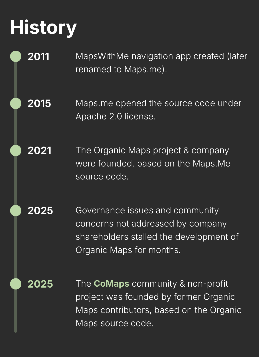
What is or will be different to organic maps, besides the governing? I have organic maps on my phone and I do not see a reason to switch for now.
You probably won’t gain much right now, but as the development on Organic Maps has stalled, you might encounter bugs not being fixed, no new features etc. If it stays like that, you’d probably want to switch at some point.
Didn’t organic maps change to comaps ?
Comaps is a fork I think. Organic maps will live on
Linger on*
Have the primary contributers moved to CoMaps as well?
Has there been any progress on the actual map data? Last time I tried Organic Maps the places I wanted to go didn’t come up in search, and when I planned a road trip with it it planned the trip hours longer than Google maps.
That sounds like an issue with the underlying OpenStreetMap data that is used by Organic Maps (and CoMaps, and OsmAnd, and others). Map quality depends on where you are in the world and who is contributing to the maps there. If data is incomplete around you, you could contribute to it (but easier said than done, I know).
I can’t say why the route would be hours longer than Google maps, but I’ve noticed OsmAnd~ tends to overestimate drive time for me (I think it overestimates delay from traffic lights). Or it could just be that calculating routes on your phone doesn’t always give results as good as calculating routes on Google’s servers.
You could use Streetcomplete to fill in the missing data yourself.
This is sick. It makes mobile updates to OSM nice and easy. Thanks for sharing!
This looks identical to Organic Maps ?
Ye I installed and it is the same. No mention of it being a fork either
I lied it says on their github
Do we think traffic data will ever be available for a project like this one? Or maybe it already is and I just don’t know.
Traffic data kind of requires driver tracking data to be sent to the cloud, which usually goes against the philosophy of projects like this. Unless they’re obtaining it from a third party, I doubt it’ll be a feature they implement.
OsmAnd seems to do this.
They predict traffic patterns based on random UUID. I don’t know how it works but it seems to be default on.
I think it would be fine if it were opt-in, but then you wouldn’t get enough data to get accurate traffic estimates
I’ve wondered if you could even if it was slowly build up a database of traffic infromation and have it be an opt in feature. Like I know in general in my city when things get busiser so I know when to avoid certain parts.
Awesome! Downloading immediately, but does anyone know why it has such a jarring transition from zooming in out? There’s such a huge change in how much information I can see from just a tiny amount of zooming.


Why not just use the Maps app if your already on iOS?


